



Saxon Switzerland National Park
Saxony’s only national park: 9,350 ha of sandstone tables, free-standing rocks and gorges above the Elbe, 40 km east of Dresden, where free climbing grew up and the Malerweg runs for 116 km.
- 36 mi²Area
- 1,824 ftElevation
- 1990Established
At a glance
- Saxony’s only national park, 9,350 ha of sandstone rocks and gorges
- Borders the Czech Bohemian Switzerland: 172 km² protected across the two parks
- 76% of the park left without intervention since 2021, meeting IUCN category II
- A cradle of free climbing, with 1,135 recognised summits in the national park region
- More than 100 viewpoints on a well-marked network of hiking trails
- The Malerweg crosses the park region in 116 km and turns 20 in 2026
Where to stay
Hotels, guesthouses and rentals around Saxon Switzerland National Park
Check availability with our partners
Affiliate links: if you book through them, we earn a commission. The price you pay does not change. How this site is funded
Nearby villages and towns
Bad SchandauClosest
5.6 mi as the crow flies
See hotelsPirna
15 mi as the crow flies
See hotels
Larger cities further away
Dresden
25 mi as the crow flies
See hotels
How the visit runs
Bad Schandau
The Nationalparkbahnhof is an international EC stop, and the S1 runs from Dresden every 30 minutes. The NationalparkZentrum opens daily from April to October, and the Kirnitzschtalbahn tram, running since 1898, starts here.
The Bastei and Kurort Rathen
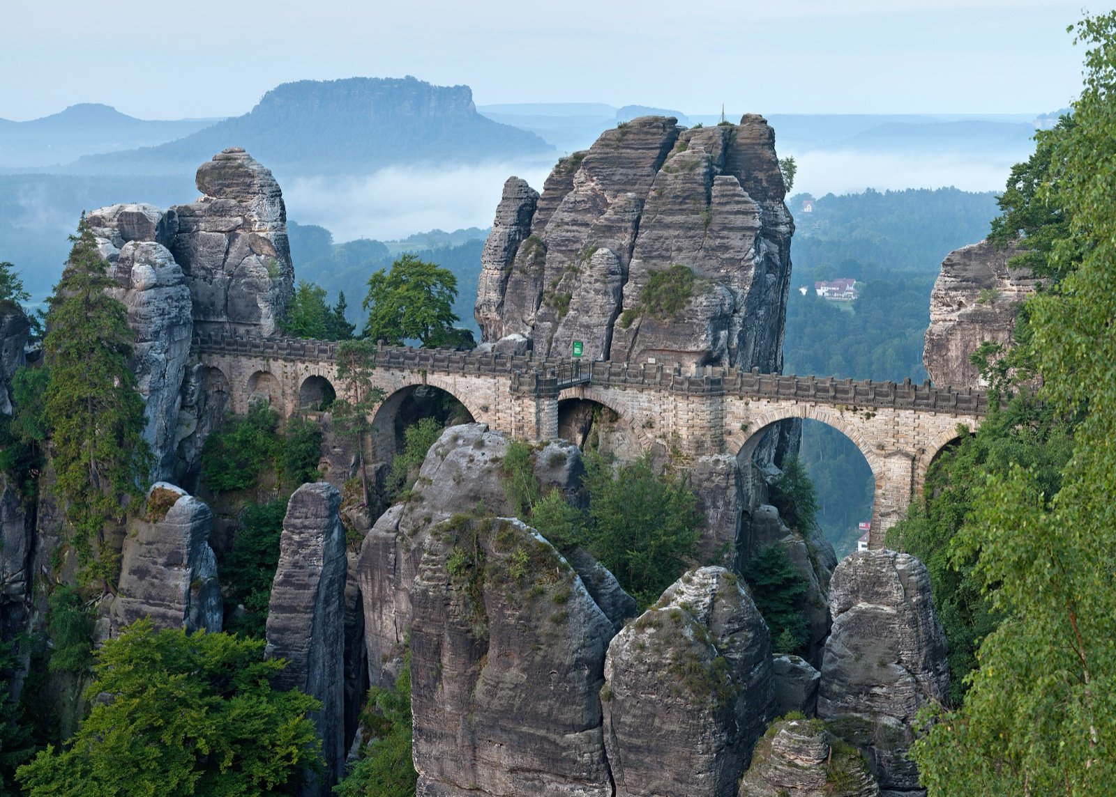
The Bastei, a rock pulpit 305 m high, rises 194 m sheer above the Elbe; a stone bridge joins it to the Felsenburg Neurathen, a 13th-century castle, and a new viewing platform opened in spring 2023. Take the S-Bahn to Kurort Rathen and the cable ferry, or the P+R Bastei shuttle every 30 minutes.
The Schrammsteine about 350 m of ascent
This chain of rocks east of Bad Schandau is climbed by steep ladders and stairs; it calls for sure feet and good shoes.
The Kuhstall
Bus or historic Kirnitzschtalbahn from Bad Schandau to Lichtenhainer Wasserfall. The rock gate is 11 m high and 17 m wide, with an inn since 1824 and the narrow Himmelsleiter stairway up to the ruins of a 15th-century castle.
Großer Winterberg from Schmilka
The quickest way up the park’s highest summit (556 m) starts at Schmilka, reached by S-Bahn and ferry, bus or car.
Hinterhermsdorf and the Obere Schleuse 20 minutes by boat
A boat trip on the 700 m reservoir of the Obere Schleuse, a weir built in 1567, has run since 1879, daily from Easter to 31 October. Five walkers’ border crossings around Hinterhermsdorf lead into Bohemian Switzerland.
Train, ferry, tram and boat: reaching the rocks without a car
| Service | From | To | Frequency |
|---|---|---|---|
| S-Bahn S1 | Dresden | Bad Schandau Nationalparkbahnhof | Every 30 minutes |
| S-Bahn, then the cable ferry across the Elbe | Kurort Rathen station | Kurort Rathen, for the Bastei | |
| P+R Bastei shuttle bus | P+R Bastei car park | The Bastei | Every 30 minutes |
| Kirnitzschtalbahn tram or bus | Bad Schandau | Lichtenhainer Wasserfall, for the Kuhstall | |
| Hiking boat | Bad Schandau | Schmilka and Hřensko | Four times a day |
Source: Nationalpark Sächsische Schweiz, arrival and destination pages (2026). Eight ferry points let you cross the Elbe; the tram has run since 1898.
Before you go
- Paths: stay on them everywhere in the park; in the core zone, only the marked trails are open.
- Waymarks: a green triangle on grey marks a mountain path for the sure-footed; a black triangle on white marks a climbers’ approach, not a hiking trail.
- Deadwood: after bark beetle attacks a large share of the park’s spruces are dead, and branches or whole trees can fall, above all in wind and rain. Some paths are declared impassable for a time.
- Fire and smoking are banned in the park, except campfires at the nine approved fireplaces. Everywhere in the forest and within 100 m of it, no open fire, barbecues, lanterns and candles included.
- Camping is banned, in cars and motorhomes too, and hiking car parks are closed to overnight parking.
- Boofen: sleeping out is allowed only for climbers, at 58 marked shelters outside the core zone, from 16 June to 31 January, with no fire, stove or cigarette.
- Dogs are welcome but must stay on a lead everywhere, and not every trail suits them.
- Drones are banned in the park, and taking off or landing is forbidden in the protected landscape too.
- Swimming and entering the water are forbidden in the park, for people and animals alike.
What is allowed
| Topic | Rule | Source |
|---|---|---|
| Wild camping (bivouac) | Restricted | Nationalparkverwaltung Sächsische Schweiz |
| Camping | Not allowed | Nationalparkverwaltung Sächsische Schweiz |
| Fires | Restricted | Nationalparkverwaltung Sächsische Schweiz |
| Dogs | Restricted | Nationalparkverwaltung Sächsische Schweiz |
| Drones | Not allowed | Nationalparkverwaltung Sächsische Schweiz |
| Swimming | Not allowed | Nationalparkverwaltung Sächsische Schweiz |
| Cycling | Restricted | Nationalparkverwaltung Sächsische Schweiz |
| Picking plants | Restricted | Nationalparkverwaltung Sächsische Schweiz |
| Climbing | Restricted | Nationalparkverwaltung Sächsische Schweiz |
Rules checked with the site manager on October 8, 2026. They can change at short notice: check before you go.
How to get there
Saxon Switzerland National ParkGateway towns
- Dresdenabout 40 kmSaxon Switzerland National Park
S-Bahn S1 to Bad Schandau every 30 minutes.
- Dresdenabout 40 kmSaxon Switzerland National Park
A17 towards Prague, exit Pirna, then the B172 to Bad Schandau or the road through Lohmen.
The Lilienstein, the only sandstone table on the right bank of the Elbe, serves as the park’s logo, and Augustus the Strong, Elector of Saxony and King of Poland, climbed it in 1708 by steps cut into its south side. Around it, the tables of the Elbe Sandstone Mountains, the Königstein among them, and the deep-cut Elbe valley set the scene for a park that continues without a break into the Czech Bohemian Switzerland.
On the right bank of the Elbe, the Großer Winterberg (1,824 ft) is the highest point of the park. Its mountain hotel dates from 1848, and the old ice house, restored in 2002, serves as a park information point.
A GDR decision and a wilderness core
- 12 September 1990: the GDR Council of Ministers decides to create the park;
- 1 October 1990: the national park is founded;
- 1 May 2021: Saxony’s state ministry in charge of the environment confirms the extension of the rest zone, where nature is left alone, to 76% of the park’s area.
Three rings of protection fit one inside the other:
- the national park, 9,350 ha;
- the Landschaftsschutzgebiet Sächsische Schweiz around it, 22,870 ha;
- the Nationalparkregion formed by the two, 38,100 ha.
Free climbing and Saxon rules over a century old
Saxon Switzerland is one of the cradles of free climbing. The park region has 13 climbing areas, and its climbing tradition has been listed as intangible cultural heritage since 2024. The Saxon climbing rules are more than a hundred years old:
- no chalk, nor any substance that adds friction;
- no climbing on wet or damp rock;
- protection with textile slings;
- the ascent ends on the summit.
Seasonal closures protect nesting birds on certain summits; the park’s list was last updated on 6 July 2026. The park also warns that illegal fires, litter and the number of people sleeping out away from the official Boofen show that a load limit has been reached.
After the storm of 31 July 2026
Late in the afternoon of 31 July 2026, a violent local storm struck the Hohnstein district of the park, around the Amselgrund and in the Polenztal, between the Bastei, Rathen and Hohnstein. The park’s first assessment:
- about 25 ha of forest hit;
- around 12,000 fallen trees expected;
- one person dead;
- the Felsenbühne Rathen open-air stage and the rest stop with its landing stage on the Amselsee damaged.
Frequently asked questions
Can you wild camp in Saxon Switzerland?
Not in the national park: camping and tents are banned, in cars and motorhomes too. Climbers may sleep out at 58 marked shelters (Boofen) outside the core zone, from 16 June to 31 January and only in direct connection with climbing; in the surrounding protected landscape, bivouac is allowed in principle and tents only on designated pitches, but not in nature reserves such as the Pfaffenstein.
How do you get to Saxon Switzerland from Dresden?
By S-Bahn: the park lies about 40 km east of Dresden, and line S1 runs to Bad Schandau every 30 minutes. By car, take the A17 towards Prague, exit at Pirna, then the B172 to Bad Schandau or the road through Lohmen.
Is the Bastei open after the July 2026 storm?
After the storm of 31 July 2026, the park’s notice said that the Basteiweg to Kurort Rathen was open and that Rathen could be reached by the cable ferry. The forest ban around the Amselgrund was still in place in early October 2026: check the park’s notices for the current situation.
Are dogs allowed in Saxon Switzerland National Park?
Yes, on a lead everywhere in the park. Not every trail suits them, so check the route first.
Can you mountain bike in Saxon Switzerland?
Only on about 50 km of official cycle routes, signed with green boards and yellow letters (Radroute). The park has no dedicated mountain bike or downhill trails, and walkers always have priority on the routes.
How long is the Malerweg?
116 km across the national park region, with nights in hotels, guesthouses or on campsites. It passes the Bastei and the Kuhstall.
Can you go climbing in Saxon Switzerland?
Yes, under the Saxon climbing rules: no chalk, no climbing on wet rock, protection with textile slings. Some summits close for a season to protect nesting birds, and the park publishes the list.
Sources
5 sources
- Nationalparkverwaltung Sächsische Schweiz consulted on October 7, 2026
- Saxon Switzerland National Park administration consulted on October 7, 2026
- OpenStreetMap consulted on October 7, 2026
- Wikidata consulted on October 7, 2026
- Wikipedia consulted on October 7, 2026