

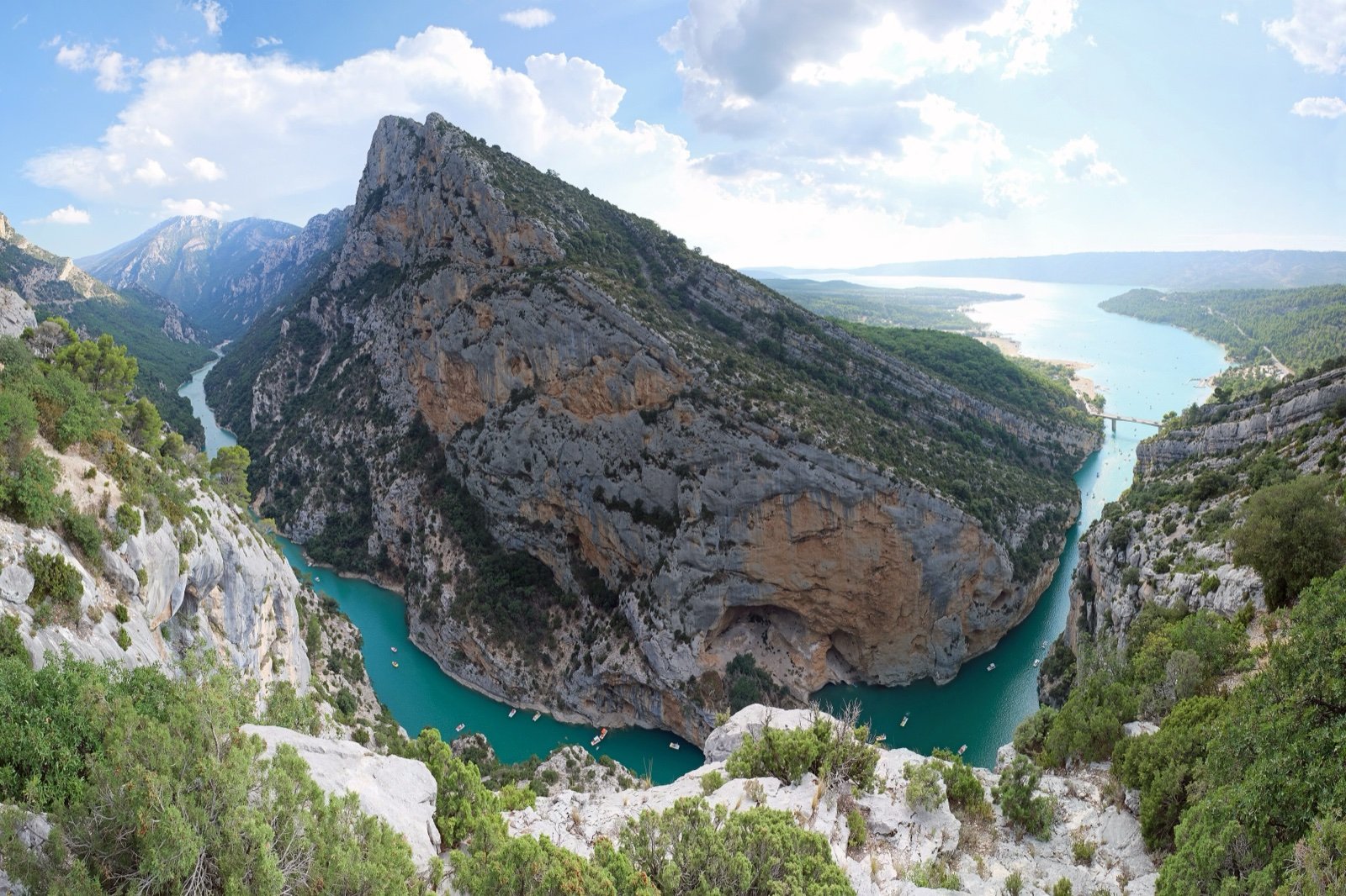
Verdon Gorge
A limestone canyon of close to 25 km, with walls up to 700 m, between Castellane and Moustiers-Sainte-Marie: free access, two corniche roads, the Blanc-Martel trail and its shuttle.
- Provence-Alpes-Côte d’Azur, France
- Gorge
- Parc naturel régional du Verdon
- 16 miLength
- 2,297 ftMaximum depth
At a glance
- A limestone canyon of close to 25 km, with walls of almost 700 m
- Access is free and never closed, although snow or wind can restrict roads
- More than 200 pairs of griffon vultures nest in the cliffs
- The Sentier Blanc-Martel: 15 km one way, about 5 h 30 without breaks, according to the Park
- About 1 h 30 by road to cross the gorge from east to west
- A classified site since 1990
Where to stay
Hotels, guesthouses and rentals around Verdon Gorge
Check availability with our partners
Affiliate links: if you book through them, we earn a commission. The price you pay does not change. How this site is funded
La Palud-sur-VerdonClosest
3.1 mi as the crow flies
See hotelsAiguines
6.8 mi as the crow flies
See hotelsMoustiers-Sainte-Marie
11 mi as the crow flies
See hotelsCastellane
11 mi as the crow flies
See hotels
Tickets and prices
| Shuttle, Adult | €8.50 |
|---|---|
| Shuttle, Child | €5.50 |
| Shuttle, Everyone | €4.50 |
Source: Parc naturel régional du Verdon (navette.parcduverdon.fr)
How the visit runs
Castellane, the eastern gateway
Base of about thirty whitewater companies, and terminus of coach line 450 from Riez.
Point Sublime 10 min on foot
A short walk leads to the viewpoint, between the paroi du Duc and the falaises de l’Escalès, both close to 400 m high; a site centre informs visitors, and discovery circuits from here take under 2 hours.
The Route des Crêtes 24 km
The road links some fifteen viewpoints with small car parks; its central part is one way, clockwise, from the Auberge des Crêtes to La Palud-sur-Verdon.
Aiguines and the left bank
On the Var side, near Aiguines, stands the belvédère du Col d’Illoire. The corniche roads of the two banks also lead to the Corniche Sublime and the balcons de la Mescla.
Moustiers-Sainte-Marie, the western gateway
The western end of the gorge, on the side of the lac de Sainte-Croix, linked to the Blanc-Martel shuttle by coach line 450.
The Blanc-Martel shuttle in 2026
| Period | Days |
|---|---|
| 3 April to 28 June | Weekends: Friday to Sunday, public holidays and bridge days |
| 29 June to 14 September | Every day |
| 17 September to 1 November | Thursday to Monday |
Source: Parc naturel régional du Verdon, 2026 season. Return trip €8.50 for adults and €5.50 for children under 12, one way to La Maline €4.50; three shuttles a day at most.
Water sports in the canyon: which days
| Activity | When | Conditions |
|---|---|---|
| Rafting, canoe-kayak, hydrospeed, floating | Dam release days only | EDF generally releases water twice a week in summer; with a company |
| Aquatic hiking | Days without a release | |
| Canyoning | Every day | |
| Canoe on your own | On the lakes of Castillon and Sainte-Croix only | |
| Full descent to the pont du Galetas | Once a season | Offered by a single company |
Source: Verdon Tourisme, read in October 2026. Guided whitewater outings cost €35 to €80 as a rule.
Before you go
- Swimming is forbidden in the Verdon between the Point Sublime and the pont du Galetas.
- Wild camping is forbidden in the canyon.
- A torch for the two tunnels of the Blanc-Martel, 100 m and 670 m long.
- Water: at least 3 litres per person on the Blanc-Martel, with a picnic, a warm layer, a hat and hiking boots.
- Dogs are banned on the Blanc-Martel and on its shuttle.
- Point Sublime parking is paid in season and meant for visits under 3 hours; another car park, on the Couloir Samson road, takes cars for the day.
- Vehicle size on the Route des Crêtes is limited to 12 m long and 3.6 m high.
- Timing: the Route des Crêtes is busiest from 15 July to 30 August; drive it before 10:00 or after 18:00.
What is allowed
| Topic | Rule | Source |
|---|---|---|
| Swimming | Not allowed | Parc naturel régional du Verdon (navette.parcduverdon.fr) |
Rules checked with the site manager on October 15, 2026. They can change at short notice: check before you go.
When to go
- Busiest period July to August
How to get there
Verdon GorgeGateway towns
- Niceabout 1 h 50Verdon Gorge
To Castellane, the eastern entrance of the gorge; indicative time, without traffic jams.
- Aix-en-Provenceabout 2 hVerdon Gorge
To La Palud-sur-Verdon; indicative time, without traffic jams.
- Marseilleabout 2 h 15Verdon Gorge
To La Palud-sur-Verdon; indicative time, without traffic jams.
- La Palud-sur-Verdon8 kmVerdon Gorge
Morning shuttle to the Chalet de la Maline, start of the Blanc-Martel.
- Point Sublime8 kmVerdon Gorge
Afternoon shuttle back to La Palud-sur-Verdon.
The Verdon has cut a limestone canyon of close to 16 mi between the Alpes-de-Haute-Provence and the Var, with vertical walls of almost 2,297 ft above the river, according to the Parc naturel régional du Verdon. Verdon Tourisme calls it the largest canyon in Europe.
A riverbed 6 to 328 ft wide, between five dams
The canyon is narrow at the bottom and wide at the top. English-language Wikipedia gives these measurements:
- 250 to 2,297 ft deep, depending on the section.
- 6 to 328 ft wide at the level of the riverbed.
- 200 to 4,921 ft from one rim to the other.
The river itself is tamed. Between 1948 and 1975, five dams were built along the Verdon and created five lakes:
- Castillon.
- Chaudanne.
- Sainte-Croix, at the western end of the canyon.
- Quinson.
- Esparron.
Upstream releases make the water level change fast, and EDF generally releases water twice a week in summer: the whitewater companies of Castellane work on those days.
Vultures, the apron and a site classified since 1990
The cliffs are a nesting site, and the river is a marker of water quality:
- Three of the four vulture species present in France nest in the gorge, with more than 200 pairs of griffon vultures.
- The apron du Rhône, an endemic fish in critical danger of extinction, signals the good quality of the water, and is one of the reasons for the swimming ban in the canyon.
The gorge has drawn explorers, walkers and protection in turn:
- 1905: Isidore Blanc and Édouard-Alfred Martel explore the gorge.
- 1928: the Touring Club de France opens the path between the Chalet de la Maline and the Point Sublime, now the Sentier Blanc-Martel.
- 1990: the site is classified under the French law on natural monuments and sites.
- 30 January 2026: date of the application file for the Grand Site de France label, led by the Parc du Verdon with seven communes; the label has not yet been awarded.
More than a million people visit the gorge each year, according to Verdon Tourisme, which gives no year.
Safety on the Blanc-Martel and by the river
The Park rates the Blanc-Martel as difficult, a walk that can be exhausting, and does not recommend it for young children or people prone to vertigo. Before setting off:
- A rockfall has closed the section between the exit of the Couloir Samson and the Point Sublime, by order of the commune of Rougon: walkers detour by the RD23A, then the GR 49, in the same time.
- The path starts with 1,312 ft of descent, and the Brèche Imbert, with its 250 steps, is easier going down: one reason to walk from La Maline to the Point Sublime.
- Ladders on the route explain why dogs and mountain bikes are banned.
- Winter brings falling stones, and July and August heat and crowds: the Park prefers spring and autumn.
- Along the river, keep away from the banks: dam releases can raise the water fast.
Conditions change with the season: check with the Park and the commune of Rougon before setting out.
Frequently asked questions
Is the Verdon Gorge free?
Yes. Access to the gorge is never closed and costs nothing, although snow or wind can restrict roads and activities. Some car parks, such as the one at the Point Sublime, are paid in season.
How long is the Verdon Gorge?
Close to 25 km, with depths of 250 to 700 m depending on the section.
Can you swim in the Verdon Gorge?
Not in the river between the Point Sublime and the pont du Galetas: swimming is forbidden there, because of dam releases and to protect the apron du Rhône.
Can you kayak through the Verdon Gorge on your own?
No. Canoeing on your own is done on the lakes of Castillon and Sainte-Croix; in the canyon, rafting and kayaking run with companies on dam release days, and the full descent to the pont du Galetas is offered by one company, once a season.
How long does the Blanc-Martel trail take?
About 5 h 30 without breaks for 15 km one way and 600 m of ascent, according to the Park. Verdon Tourisme gives 16 km and 6 hours.
When is the best time to visit the Verdon Gorge?
Spring and autumn for the Blanc-Martel, according to the Park, which advises against July and August (heat, crowds) and winter (falling stones).
Is the Route des Crêtes open in winter?
No. The road is open from the end of March to the end of November.
Sources
8 sources
- Parc naturel régional du Verdon consulted on October 28, 2026
- Parc naturel régional du Verdon (navette.parcduverdon.fr) consulted on October 20, 2026
- Parc naturel régional du Verdon (parcduverdon.fr) consulted on October 15, 2026
- Verdon Tourisme (verdontourisme.com) consulted on October 15, 2026
- OpenStreetMap consulted on October 19, 2026
- Wikidata consulted on October 28, 2026
- Wikipedia (en) consulted on October 15, 2026
- Wikipedia (fr) consulted on October 28, 2026