
Tour du Mont Blanc
A 170 km loop with 10,000 m of ascent around the Mont-Blanc massif through France, Italy and Switzerland, in 7 to 12 days from Les Houches: booking the huts, half-board budgets, the bivouac rules of each valley and the season.
- France
- Trek
- 106 mi
- 7 to 12 days
At a glance
- 170 km and about 10,000 m of ascent around the massif, through France, Italy and Switzerland
- 7 to 12 days; the 9 to 10 day format, 15 to 20 km a day, is the most chosen
- Season from mid-June to mid-September; névés and buried signs still possible in June
- Huts at €65 to €95 a night in half-board dormitories; bookings for 2027 open from 15 October 2026
- Bivouac banned below 2,500 m in the Aosta Valley and in the Contamines-Montjoie reserve
- Well waymarked and no mountaineering gear needed, but a col to climb every day
Stages
Les Houches to Les Contamines-Montjoie
The classic start, leaving Les Houches anticlockwise; a variant runs from the col de Voza over the col de Tricot. The sources give no official stage split: these seven sections follow the key points of the anticlockwise route page, not fixed days.
Les Contamines to Les Chapieux
Past Notre-Dame-de-la-Gorge, the Nant Borrant and La Balme refuges and the col du Bonhomme; the col des Fours variant reaches 2,665 m. Les Chapieux has an official bivouac area with sanitation.
Les Chapieux to Courmayeur
Over the col de la Seigne into Italy, past the Casermetta, then down the Val Veny towards Courmayeur, where free shuttles serve the valley.
Courmayeur to La Fouly
Up to the Rifugio Bertone at 2,000 m and on to the Rifugio Bonatti, then the col Grand Ferret into Switzerland and the Alpage de La Peule at 2,100 m; the Petit Col Ferret is a variant.
La Fouly to Champex-Lac
From La Fouly on to Champex-Lac, where the Relais d’Arpette has 100 places at 1,631 m.
Champex-Lac to Trient
By the col de la Forclaz, or by the difficult fenêtre d’Arpette variant at 2,665 m past the lac d’Arpette and the Chalet du Glacier; Trient and its pink church, with Le Peuty just beyond.
Trient to Les Houches
Over the col de Balme back into France, then the col des Posettes, Tré-le-Champ and La Flégère to the col du Brévent and Les Houches. Variants lead from Vallorcine towards the Buet, or from the col de Balme by the Chalet de Charamillon and Le Tour.
Bivouac and camping, valley by valley
| Area | Rule | Where a night is possible |
|---|---|---|
| Aosta Valley (Italy) | All camping banned; bivouac banned below 2,500 m | Almost nowhere on the Italian section |
| Valais (Switzerland) | Bivouac and wild camping banned in general | One night, not in a group, above the treeline; campsites at La Fouly, Champex-Lac, Arpette, Peuty, Stand and the col de la Forclaz |
| Chamonix | Camping banned outside sites since 1992 | Bivouac at altitude from sunset to sunrise, except the Lac Blanc, the Blaitière pastures and the col des Posettes |
| Aiguilles Rouges nature reserves | Bivouac regulated from 1 June to 30 September; no dogs, fires, swimming or drones | With compulsory booking on reserve-bivouac74.fr |
| Contamines-Montjoie nature reserve | Bivouac banned below 2,500 m | Two small areas (Giettaz at the Pont de la Rollaz, La Balme) and the leisure park area, 150 places, from 7 pm to 9 am, with booking |
| Vallorcine | Wild camping and fires banned | One night tolerated from 7 pm to 9 am outside the reserve, in practice above 1,700 m |
| Les Chapieux | No bivouac in the vallée des Glaciers (private pastures) | Official bivouac area with sanitation and waste collection |
Source: Mon Tour du Mont-Blanc, bivouac page (read October 2026). A bivouac is one night from sunset to sunrise without a fire; wild camping means several days away from any site.
Three paces for the same loop
| Format | Days | Daily distance | For whom |
|---|---|---|---|
| Sporty | 7 | Fit hikers | |
| Balanced | 9 to 10 | 15 to 20 km | The most chosen format |
| Contemplative | 11 to 12 | Slower walkers; children from age 10 |
Source: Mon Tour du Mont-Blanc, planning pages (read October 2026). Autour du Mont-Blanc gives 7 to 10 days and about 60 hours of walking.
Before you go
- Bookings: strongly recommended for July and August, when some huts are full several months ahead; the platform opens the summer 2027 season from 15 October 2026 and lists member huts only, not every refuge in the massif.
- Cancellation: more than 30 days before, 80% of the deposit is refunded; under 30 days, nothing without insurance.
- Budget: €65 to €95 a night for a half-board dormitory, so €500 to €900 of nights for 7 to 10 days.
- Hut evenings: arrival between 4 pm and 6 pm, dinner around 6:30 to 7 pm, lights out around 10 pm.
- Pack: 35 to 45 litres and 8 to 12 kg at most, with broken-in waterproof boots on Vibram soles, a waterproof jacket, a three-layer system, poles and a silk liner; train beforehand with 8 to 10 kg on your back.
- Dogs: possible but hard, says the platform: banned in the Contamines-Montjoie and Chamonix valley reserves, refused on the Les Chapieux shuttles and the cable cars, exposed to herds and their guard dogs, and to check hut by hut.
- Children: from age 10, by splitting the loop into 10 to 12 days; not recommended with a baby.
- Phone: no network from the Pont Romain at Les Contamines to the lac Combal, by way of Les Chapieux and the col de la Seigne.
- Fitness: 5 to 8 hours of walking a day for several days in a row, with stages of 10 to 20 km and ascents that can exceed 1,000 m.
Huts and where to stay
Mountain huts
Gîte Alpage de La Peule
6,890 ft · 38 beds
Rifugio G. Bertone
6,562 ft · 50 beds
Chalet Alpin du Tour (FFCAM)
4,810 ft · 87 beds
Cabane du Combal
6,457 ft · 23 beds
Refuge de la Balme
5,597 ft · 39 beds
Auberge-Refuge de la Nova
5,098 ft · 61 beds
Refuge Le Peuty
4,357 ft · 19 beds
Refuge des Mottets
6,115 ft · 80 beds
Refuge des Prés
6,348 ft · 30 beds
See 4 more huts
Rifugio Maison Vieille
6,417 ft · 40 beds
Rifugio Monte Bianco - Cai Uget
5,577 ft · 70 beds
Refuge de Nant Borrant
4,787 ft · 37 beds
Relais d'Arpette
5,351 ft · 100 beds
When to go
- Busiest period July to August
What is allowed
| Topic | Rule | Source |
|---|---|---|
| Wild camping (bivouac) | Restricted | Espace Mont-Blanc (autourdumontblanc.com) |
| Camping | Restricted | Espace Mont-Blanc (autourdumontblanc.com) |
| Dogs | Restricted | Mon Tour du Mont-Blanc |
Rules checked with the site manager on October 15, 2026. They can change at short notice: check before you go.
The Tour du Mont-Blanc circles the massif through three countries, France, Italy and Switzerland, in about 106 mi and 32,808 ft of ascent, the figures of Autour du Mont-Blanc, the portal of the Espace Mont-Blanc; the English Wikipedia counts about 103 mi. The Espace Mont-Blanc, a cooperation between Savoie, Haute-Savoie, the Aosta Valley and the Valais, promotes the route through its portal, and the Association des Gardiens de Refuges du TMB runs the booking platform for its member huts.
A baroque chapel, a pink church and two passes at 8,743 ft
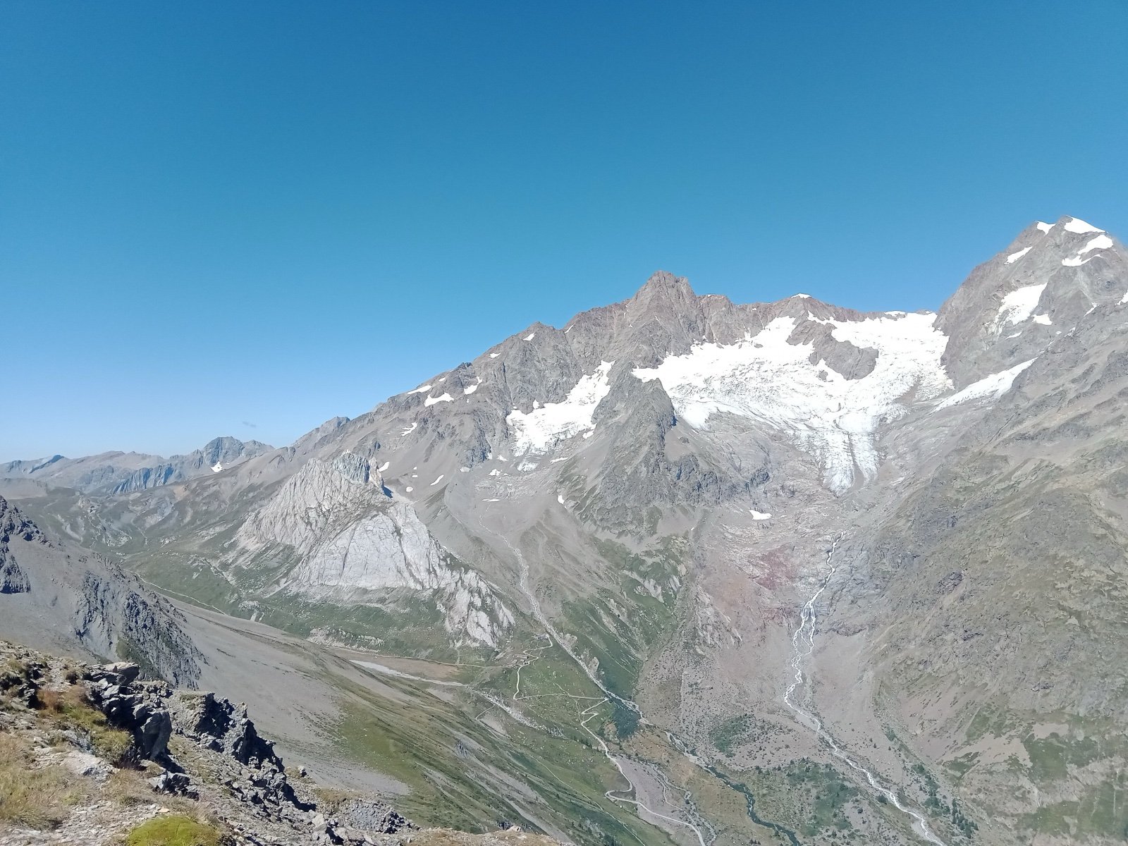
The route never needs mountaineering equipment, but every day crosses a col, and the landmarks the official sites single out are for the most part passes and the villages between them:
- Notre-Dame-de-la-Gorge, the baroque chapel at the head of the Val Montjoie where the path to the col du Bonhomme begins.
- The col de la Seigne, the emblematic crossing from France into Italy, with the Mont-Blanc massif and the Val Veny in view; on the Italian side, the Casermetta, a cross-border environmental education centre with a model of the massif, opens officially from 25 June 2026.
- Courmayeur, a historic centre of alpine character surrounded by villages, the Italian stage of the loop.
- The pink church of Trient, the landmark of the Swiss stage.
- The highest points, according to Wikipedia: the col des Fours in France and the fenêtre d’Arpette in Switzerland, both at 8,743 ft and both on variants, the Arpette one being difficult; the route sheet of Autour du Mont-Blanc gives 8,530 ft as the maximum altitude.
Between the summit of the Brévent and the col de la Croix du Bonhomme the loop shares its path with the GR 5, which runs from the North Sea to the Mediterranean. The same trail hosts the annual Ultra-Trail du Mont-Blanc, whose best runners cover the whole distance in under 24 hours.
Three countries, three waymarks, and the same good practice
The markings change at each border, but a green TMB logo, round or square, is common to the whole loop:
- France: the white and red marks of the GR.
- Italy: yellow marks.
- Switzerland: yellow marks, or white-red-white.
The official sites distinguish a bivouac, one night from sunset to sunrise without a fire, from wild camping, several days away from any site, and the rules for each differ by valley. Everywhere, the same requests: no swimming in the mountain lakes, no picking plants, no fires, and all waste carried down, even biodegradable, because not every refuge is equipped to sort it. In the huts, shoes come off at the door and dormitories stay quiet.
80,000 hikers a year, and rooms sold out months ahead
The FFRandonnée reported in August 2026 that some 80,000 hikers walk the loop each year, at times less than a metre apart, and that agencies monopolise bookings at the expense of independent hosts. Local press counted 44,322 walkers between 6 June and 1 September of one season. The platform’s own notes on the season:
- June is the adventure version: residual snow, paths hard to make out, map navigation essential, flowers at their peak.
- July and August bring the most hikers and the most services open; some huts are full months ahead.
- September means short, cool days and quieter paths: the period the refuge wardens themselves prefer.
The classic anticlockwise direction is the best waymarked; walking clockwise can free up beds. First-timers are advised to try a two-day, one-night discovery stage before committing to the full loop.
Trains to Chamonix and Martigny, buses through the tunnel, free shuttles in the Italian valleys
The loop can be reached by train and bus from all three countries, and the public transport along it lets you shorten or skip a stage:
- French side: the Martigny to Vallorcine, Chamonix and Saint-Gervais railway, valley buses, a shuttle from Les Contamines to Notre-Dame-de-la-Gorge, and the lifts of the col de Balme at Le Tour, the Flégère and the Brévent.
- Les Chapieux: shuttles to the Ville des Glaciers and to Bourg-Saint-Maurice, which take no dogs and cannot be booked ahead.
- Italian side: Courmayeur through the Mont-Blanc tunnel by the Chamonix, Courmayeur and Aosta bus; free shuttles into the Val Veny (La Visaille) and the Val Ferret (Arp Nouvaz).
- Swiss side: La Fouly and Champex-Lac by the Swiss buses and trains (Champex to Martigny; Martigny to the col de la Forclaz and Trient), a network reliable enough to adjust stages on the way.
Frequently asked questions
How long is the Tour du Mont Blanc?
About 170 km with 10,000 m of ascent, according to Autour du Mont-Blanc, through France, Italy and Switzerland; the English Wikipedia gives about 165 km. Stages run from 10 to 20 km.
How many days does the Tour du Mont Blanc take?
7 to 12 days: 7 for fit hikers, 9 to 10 for the balanced format most people choose, with 15 to 20 km a day, 11 to 12 at a contemplative pace. Autour du Mont-Blanc counts about 60 hours of walking.
Do you need to book the refuges on the Tour du Mont Blanc?
In practice yes: booking is recommended for July and August, and some huts are full several months ahead. Bookings for summer 2027 open from 15 October 2026 for the member refuges of the Association des Gardiens.
How much does the Tour du Mont Blanc cost?
€65 to €95 a night in a half-board dormitory, so €500 to €900 of accommodation for 7 to 10 days, by the platform’s estimate.
When is the best time to walk the Tour du Mont Blanc?
Mid-June to mid-September is the classic season. September has short, cool days and quieter paths and is the refuge wardens’ favourite; July and August are the busiest, with the most services open; June still has snow.
Can you camp on the Tour du Mont Blanc?
In a few places and under strict rules. The Aosta Valley bans all camping and any bivouac below 2,500 m; the Valais allows one night above the treeline, outside a group; in France a bivouac is tolerated from sunset to sunrise, with compulsory booking in the Aiguilles Rouges reserves and set areas at Les Contamines and Les Chapieux.
Which direction should you walk the Tour du Mont Blanc?
Anticlockwise from Les Houches is the classic and best waymarked direction, through Les Contamines, Les Chapieux, Courmayeur, La Fouly, Champex-Lac and Trient. Clockwise can open up availability in the huts.
Where does the Tour du Mont Blanc start?
Les Houches is the classic start, but the loop can begin at Courmayeur, Chamonix, Les Contamines, Saint-Gervais, Les Chapieux, Orsières (Champex or La Fouly), Trient or Vallorcine, all reachable by train or bus.
Sources
6 sources
- Association des Gardiens de Refuges du Tour du Mont-Blanc consulted on October 16, 2026
- Espace Mont-Blanc (autourdumontblanc.com) consulted on October 15, 2026
- Mon Tour du Mont-Blanc consulted on October 15, 2026
- OpenStreetMap consulted on October 15, 2026
- Wikidata consulted on October 15, 2026
- Wikipedia consulted on October 16, 2026