

West Highland Way
154 km from Milngavie to Fort William in six to seven days: booking beds ahead, the camping byelaws after Drymen, the Devil’s Staircase at 550 m and the train to both ends.
- United Kingdom

- Trek
- 96 mi
- 5 to 7 days
At a glance
- 154 km from Milngavie to Fort William, Scotland’s first Long Distance Route, opened in 1980
- Six to seven days on average; the manager’s suggested plans run from five to seven
- Highest point at the top of the Devil’s Staircase, 550 m, between Kingshouse and Kinlochleven
- Book beds ahead in every season: some areas have limited availability, and nights are in hotels, B&Bs, bunkhouses and campsites
- Camping byelaws in the national park from 1 March to 30 September, once past Drymen
- May is the busiest month; more than 40,000 walkers finish the Way each year
Stages
| # | Stage | Distance | Ascent | Descent | Overnight |
|---|---|---|---|---|---|
| 1 | Milngavie → Drymen | 12 mi | |||
| 2 | Drymen → Rowardennan | 15 mi | |||
| 3 | Rowardennan → Inverarnan | 14 mi | |||
| 4 | Inverarnan → Tyndrum | 12 mi | |||
| 5 | Tyndrum → Inveroran | 9 mi | |||
| 6 | Inveroran → Kingshouse | 10 mi | |||
| 7 | Kingshouse → Kinlochleven | 9 mi | |||
| 8 | Kinlochleven → Fort William | 15 mi | |||
| Total | 96 mi |
Milngavie to Drymen 19 km
A flat introduction on footpaths, tracks and lanes with no major climb, between 19 and 140 m above sea level, from the obelisk on Douglas Street in the centre of Milngavie.
Drymen to Rowardennan 24 km
The one significant ascent is Conic Hill, near Balmaha, with a low-level alternative. Between Balmaha and Rowardennan the path is narrow and eroded in places, with many steps and roots.
Rowardennan to Inverarnan 22.5 km
Forest track, then an ever rockier path along the wilder northern shore of Loch Lomond, between 7 and 105 m. The section ends at the Drovers Inn in Inverarnan.
Inverarnan to Tyndrum 19.5 km
An old military road over moderate hills, from 17 to 336 m, past the Falls of Falloch and Kirkton Farm. Tyndrum is the last place to buy food before Kinlochleven.
Tyndrum to Inveroran 14.5 km
The most straightforward day on the Way, on good paths, with the pyramid of Beinn Dorain ahead. After Bridge of Orchy, a short climb on the old military road opens a viewpoint over Loch Tulla and the Black Mount.
Inveroran to Kingshouse 16 km
The crossing of Rannoch Moor, between 168 and 446 m, with no shelter until the Glencoe Ski Centre.
Kingshouse to Kinlochleven 14.5 km
The Devil’s Staircase zigzags up to 550 m, the highest point of the Way, marked by a cairn, before the long drop to Kinlochleven.
Kinlochleven to Fort William 24 km
A steep climb out of Kinlochleven, then the Lairigmor, rough underfoot, and views of Ben Nevis before the finish at the statue of a walker in Gordon Square.
Book your nights
8 nights to plan on this route. Tick each one once it is booked: this page remembers it on this device.
0 of 8 nights booked
Affiliate links: if you book through them, we earn a commission. The price you pay does not change. How this site is funded
- Booking.com
- Booking.com
- Booking.com
- Booking.com
- Booking.com
- Booking.com
- Booking.com
- Booking.com
Where to join or leave the Way
| Place | Train | Bus | Cash machine |
|---|---|---|---|
| Milngavie | Regular trains from Glasgow | Yes | |
| Drymen | Yes | ||
| Ardlui (across the loch by ferry) | West Highland Railway | ||
| Inverarnan | CityLink Glasgow to Fort William | ||
| Crianlarich (link path) | West Highland Railway | CityLink Glasgow to Fort William | Yes |
| Tyndrum | West Highland Railway | CityLink Glasgow to Fort William | Yes |
| Bridge of Orchy | West Highland Railway | CityLink Glasgow to Fort William | |
| Kinlochleven | Yes | ||
| Fort William | Trains to Glasgow | CityLink; Ember electric bus to Edinburgh | Yes |
Source: West Highland Way Management Group, travel and FAQ pages (read October 2026).
Camping along the Way: two sets of rules
| Where and when | What applies | Fires |
|---|---|---|
| Inside Loch Lomond and The Trossachs National Park (entered after Drymen), 1 March to 30 September | Camping byelaws: campsites and permit areas only | Covered by the same byelaws |
| Outside the park, or outside those dates | Scottish Outdoor Access Code: light wild camping permitted, two or three nights in the same place |
Source: West Highland Way Management Group, FAQ and Milngavie to Drymen section page (read October 2026).
Before you go
- Accommodation: book ahead at any time of year, since some areas have limited availability.
- Start day: at busy times, beds are easier to find if you avoid starting on a Saturday; May is the most popular month.
- Camping: inside Loch Lomond and The Trossachs National Park, which the Way enters after Drymen, camping and fire-lighting byelaws apply from 1 March to 30 September, so campsites and permit areas only. Elsewhere, the Scottish Outdoor Access Code allows light wild camping, two or three nights in one place.
- Dogs are welcome under proper control, but the two enclosed fields on the eastern approach to Conic Hill are closed to them during lambing, about six weeks from mid-April to the end of May, even on a lead.
- Midges are most active from June to August, at dusk and dawn; they fly little in a breeze.
- Ticks can carry Lyme disease: long clothing, repellent and a check every evening.
- Cash: cash machines at Milngavie, Drymen, Crianlarich, Tyndrum, Kinlochleven and Fort William.
- Food: Tyndrum is the last chance to stock up; there are no more shops until Kinlochleven.
- Winter: from November to March expect winter conditions; the manager asks that walkers be fit, able to navigate by map and compass, and equipped for them.
When to go
- Busiest period May
What is allowed
| Topic | Rule | Source |
|---|---|---|
| Camping | RestrictedMarch to September | West Highland Way (site officiel) |
| Fires | RestrictedMarch to September | West Highland Way (site officiel) |
| Dogs | Allowed | West Highland Way (site officiel) |
| Cycling | Allowed | West Highland Way Management Group |
Rules checked with the site manager on October 16, 2026. They can change at short notice: check before you go.
The West Highland Way was Scotland’s first Long Distance Route, opened on 6 October 1980, and a NatureScot manager calls it the most popular of the country’s 29 Great Trails. Its 96 mi run from the town of Milngavie to Fort William, from a country park to the lochs, open moorland and steep mountains of the Highlands, with nights spent in hotels, B&Bs, bunkhouses and campsites.
Tom Hunter’s idea, approved in 1974 and opened by Lord Mansfield
According to Wikipedia, the idea of an official trail came from Tom Hunter, from Glasgow, in part to protect the eastern shore of Loch Lomond; the geographer Fiona Rose surveyed the line at the start of the 1970s. Three dates follow:
- 1974: the trail is approved for development.
- 6 October 1980: official opening by Lord Mansfield.
- October 2020: the manager counts more than 40,000 walkers completing the Way each year, a figure more than doubled by those who walk short sections.
The route is run by the West Highland Way Management Group, which brings together the councils of East Dunbartonshire, Stirling, Argyll and Bute and Highland, with Loch Lomond and The Trossachs National Park as lead body. Wikipedia puts the number of people finishing the whole route at about 45,000 a year as of 2023, with a similar number walking individual sections, and estimates the path’s contribution to the local economy at 5.5 million pounds a year.
Loch Lomond’s goats, Rannoch Moor and the glen of the 1692 massacre
The Way is usually walked from south to north, because the southern sections are easier and prepare for the more demanding ground further north. The landscape changes with each section:
- Loch Lomond’s eastern shore, more remote north of Rowardennan: you may meet wild goats and glimpse golden eagles and ospreys, the RSPB reserve at Inversnaid gives advice, and the path crosses the Inversnaid waterfall on a footbridge where it drops into the loch.
- Between Inverarnan and Tyndrum, the Falls of Falloch, then the ruins of St Fillan’s Priory and a graveyard at Kirkton Farm, along an old military road.
- Rannoch Moor, described by the manager as one of the last great wildernesses of Europe, crossed between Inveroran and Kingshouse with Ba Bridge at its midpoint.
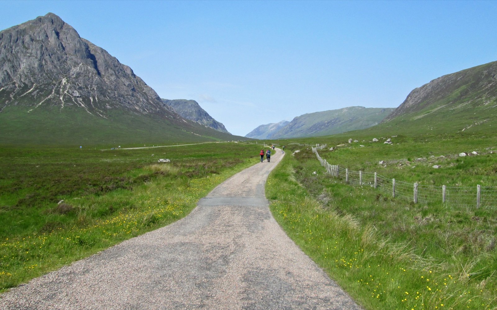
- Buachaille Etive Mor, one of Scotland’s best-known Munros, and Glen Coe, scene of the massacre of Clan MacDonald in 1692, both seen from the Devil’s Staircase.
- Ben Nevis, in view on the final section beyond the Lairigmor; Kinlochleven has the National Ice Climbing Centre.
Trains to Milngavie, CityLink coaches, and no car park at either end
Milngavie is well served by regular trains from Glasgow, and trains run back from Fort William to Glasgow, so the whole walk works without a car. Along the route:
- Railway stations at Ardlui, Crianlarich, Tyndrum and Bridge of Orchy, on the West Highland Railway; Crianlarich, the halfway point, is bypassed to the west and reached by a link path.
- The CityLink bus from Glasgow to Fort William stops at Inverarnan, Crianlarich, Tyndrum, Bridge of Orchy and Glen Coe; from Fort William, the Ember electric bus runs to Edinburgh.
- No dedicated car park exists at either end: drivers leave their car in front of Milngavie station, free at the time of reading but sometimes full. Along Loch Lomond, parking is restricted to the public car parks at Balmaha and Rowardennan.
Cyclists and horse riders have the same access rights as walkers in Scotland, provided they exercise them with care, but the path was designed for walking: it passes under the A82 and the railway, and the stretch from Rowardennan to Inverarnan is rocky and narrow. A footbridge and a section of path just north of Inversnaid were replaced in 2023.
Eight sections, five to seven days, and the Notices page
The manager publishes eight sections but says they need not be treated as a day’s walk each: the length of your days depends on your fitness and what you want from the trip. What its pages say about pacing:
- On average the Way takes six to seven days; the suggested itineraries range from five to seven.
- The five-day plan ends its days at Balmaha, Inverarnan, Bridge of Orchy and Kinlochleven.
- Some walkers find the stretch at the northern end of Loch Lomond, from Inversnaid to Inverarnan, much slower and more difficult than expected.
- The route is waymarked along its length, yet walkers are expected to be able to read a map and use a compass.
- Diversions, works and known problems are posted in the Notices section of the official site: in 2026 it announced an alternative high route into Fort William (3 June) and the reopening of the Rowchoish Bothy (9 July).
Frequently asked questions
How long is the West Highland Way?
154 km, from Milngavie to Fort William, in eight official sections of 14.5 to 24 km each.
How many days does it take to walk the West Highland Way?
Six to seven days on average, according to the manager, whose suggested itineraries range from five to seven days. The eight sections are not meant to be eight days.
Which direction should you walk the West Highland Way?
From south to north, Milngavie to Fort William, as most people do: the southern sections are easier and build up to the more demanding northern ones.
Can you wild camp on the West Highland Way?
Yes, under the Scottish Outdoor Access Code, for two or three nights in the same spot, except inside Loch Lomond and The Trossachs National Park from 1 March to 30 September, where byelaws restrict camping to campsites and permit areas.
Are dogs allowed on the West Highland Way?
Yes, kept under proper control. The two enclosed fields on the eastern approach to Conic Hill are closed to dogs during lambing, from about mid-April to the end of May, even on a lead.
When is the best time to walk the West Highland Way?
Spring and autumn, which the manager describes as especially beautiful. May is the most popular month, and from November to March winter conditions can be expected.
How do you get to the start of the West Highland Way?
By regular train from Glasgow to Milngavie. There is no dedicated car park at either end; parking in front of Milngavie station was free at the time of reading but is sometimes full.
What is the highest point of the West Highland Way?
550 m, at the top of the Devil’s Staircase between Kingshouse and Kinlochleven, marked by a cairn.
Sources
5 sources
- West Highland Way (site officiel) consulted on October 15, 2026
- West Highland Way Management Group consulted on October 16, 2026
- OpenStreetMap consulted on October 15, 2026
- Wikidata consulted on October 15, 2026
- Wikipedia consulted on October 21, 2026