
Victoria Falls
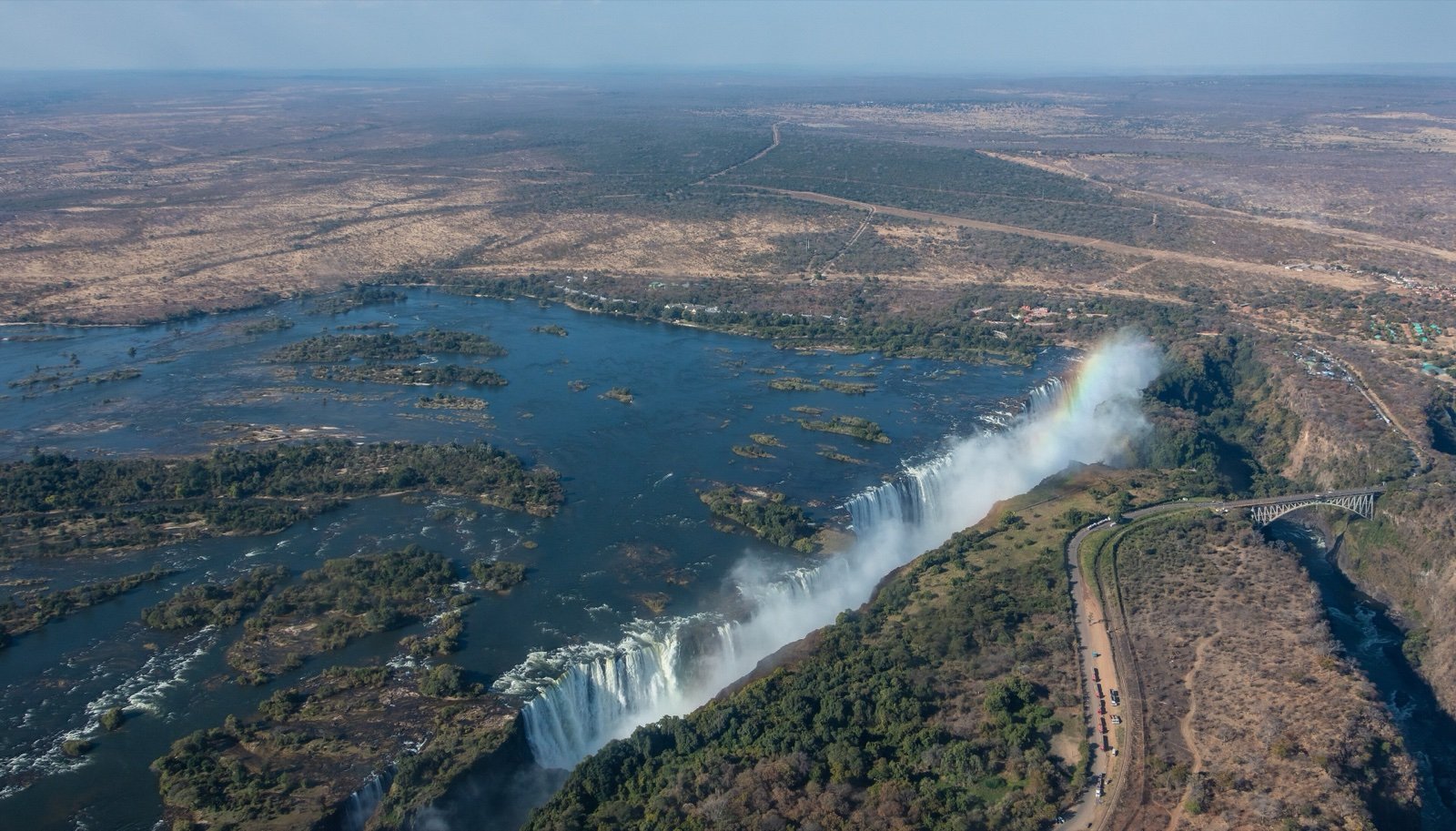
The Zambezi drops 108 m into a single basalt gorge between Zambia and Zimbabwe, raising spray more than 400 m high: four falls, Livingstone Island and a flow that changes tenfold between April and November.
At a glance
- A drop of 108 m at the centre of the curtain
- A curtain about 1.7 km wide, split into four falls
- Spray rising more than 400 m, visible from up to 50 km
- A moonbow in the spray at full moon
- In November the flow drops to about a tenth of April’s
- UNESCO natural World Heritage since 1989
Where to stay
Hotels, guesthouses and rentals around Victoria Falls
Check availability with our partners
Affiliate links: if you book through them, we earn a commission. The price you pay does not change. How this site is funded
Victoria FallsClosest
1.9 mi as the crow flies
See hotelsLivingstone
5 mi as the crow flies
See hotels
Victoria Falls through the seasons
| Period | The river | What you see |
|---|---|---|
| February to May | Flood season, peak in April (around March and April for Zambia Tourism) | Spray hides the foot and face of the falls; spectacular from the air |
| After the flood, to about September | Falling | Zambia Tourism’s pages differ: best April to about July on one, improving until about September on another |
| October | Dry season at its peak; as a rule the hottest and driest month | Parts of the falls dry up; the Zambian side is often bare rock |
| November and December | Minimum flow in November, about a tenth of April’s | Trickles, some sections dry, basalt cliffs easier to see |
Sources: Zambia Tourism; Wikipedia (Victoria Falls), read in October 2026.
The Zambian bank and the Zimbabwean bank
| Bank | Park | Gateway town | Nearest airport | Also there |
|---|---|---|---|---|
| Zambia (east) | Mosi-oa-Tunya National Park, 66 km² | Livingstone, about 11 km | Livingstone, 15 km from the falls by road | Eastern Cataract, Knife-edge Bridge, steep path to the Boiling Pot |
| Zimbabwe (west) | Victoria Falls National Park, 23 km² | Victoria Falls, facing the falls | Victoria Falls (VFA), 18 km south of the town | Devil’s Cataract; walk to the bottom of the First Gorge in low water |
Sources: Zambia Tourism; Wikipedia (Victoria Falls, airports), read in October 2026.
Before you go
- Raincoat: at the peak of the flood, a raincoat or an umbrella may be needed on the paths.
- Full width: in high water the spray hides the falls, and their whole width cannot be seen on foot.
- Heat: October tends to be the hottest and driest month.
- Low water: from October parts of the falls dry up, and in November and December some sections carry only trickles.
- Boiling Pot: the footpath down from the Zambian side is steep.
- Devil’s Pool and Livingstone Island: trips there are very seasonal and start only once the current has slowed, around the middle of the year, according to a tourism portal.
When to go
- Peak water flow March to April
How to get there
Victoria FallsGateway towns
- Livingstoneabout 11 kmVictoria Falls
South on Mosi-oa-Tunya Road; just before the border, a right turn leads to the car park where the paths start.
- Livingstone airport15 kmVictoria Falls
By road to the falls; the airport is 5 km from the centre of Livingstone.
- Lusaka470 kmVictoria Falls
By road to Livingstone, then about 11 km to the falls.
At Victoria Falls the whole Zambezi pours into the First Gorge, then leaves it through one gap 361 ft wide, two thirds of the way along the curtain from the west. The falls mark the border between Zambia and Zimbabwe: Mosi-oa-Tunya National Park covers 25 mi² on the Zambian bank, Victoria Falls National Park 8.9 mi² on the Zimbabwean one.
Four falls, two islands and a 354 ft gorge
By combined width and height, the falls are described as the largest sheet of falling water in the world. The curtain is about 1.1 mi wide, and its parts follow one another from Zimbabwe in the west to Zambia in the east:
- Devil’s Cataract, at the Zimbabwean end.
- The Main Falls.
- Rainbow Falls, the highest of the four.
- The Eastern Cataract, at the Zambian end.
Two islands sit on the crest: Boaruka, also called Cataract Island, near the western bank, and Livingstone Island near the middle. Below, the First Gorge is 262 ft deep at its western end and 354 ft in the centre.
- The Boiling Pot, a whirlpool at the bend of the river below the falls, is reached by a steep footpath from the Zambian side.
- The Victoria Falls Bridge, a steel arch over the Batoka Gorge, links the two countries.
- On the Zimbabwean side, you can walk down to the bottom of the First Gorge in low water.
The smoke that thunders, from Lozi names to 1855
Mosi-oa-Tunya, the Lozi name kept by the Zambian park, means “the smoke that thunders”; the Tonga name, Shungu Namutitima, means “boiling water”. The spray earns both:
- As a rule it rises more than 1,312 ft, sometimes twice as high.
- It can be seen from up to 31 mi away.
- At full moon it produces a lunar rainbow, the moonbow.
David Livingstone, the first European recorded to have seen the falls, looked at them on 16 November 1855 from the island that now bears his name. UNESCO inscribed the site as natural World Heritage in 1989.
Mosi-oa-Tunya beyond the falls
The Zambian park stretches for about 7.5 mi along the Zambezi upstream of the falls. Its wildlife includes:
- Southern white rhinoceroses, the only ones in Zambia.
- Elephants, seen mostly in the dry season.
The Zimbabwean bank has historically drawn many more visitors than the Zambian one, thanks to its visitor facilities. From September to December the flow shows a falling trend, sharper in drought years, which are becoming more frequent.
Frequently asked questions
Is Victoria Falls in Zambia or Zimbabwe?
Both: the falls lie on the Zambezi, on the border. The Zambian bank is Mosi-oa-Tunya National Park, near Livingstone; the Zimbabwean bank is Victoria Falls National Park, beside the town of Victoria Falls.
How high is Victoria Falls?
108 m at the centre of the curtain. The First Gorge below is 80 m deep at its western end.
When is the best time to see Victoria Falls?
After the flood peak: Zambia Tourism places the flood peak around March and April, when spray hides much of the falls. Its pages disagree on the best months: April to about July on one, a view that improves until about September on another. Both agree that parts dry up from October.
Is there water at Victoria Falls in November?
Less: the minimum flow, in November, is about a tenth of April’s. From September to January up to half of the rock face can be dry, but the basalt cliffs show.
How far is Livingstone from Victoria Falls?
About 11 km south along Mosi-oa-Tunya Road, according to Zambia Tourism. From the town of Victoria Falls, Livingstone is about 16 km away across the old railway bridge.
Which airport is closest to Victoria Falls?
Livingstone airport, 15 km by road from the falls, with direct flights from Lusaka, Cape Town, Nelspruit, Johannesburg and Nairobi. On the Zimbabwean side, Victoria Falls airport is 18 km south of the town.
Sources
7 sources
- Tourism consulted on October 14, 2026
- OpenStreetMap consulted on October 14, 2026
- Wikidata consulted on October 14, 2026
- Wikipedia (de) consulted on October 14, 2026
- Wikipedia (en) consulted on October 14, 2026
- Wikipedia (es) consulted on October 14, 2026
- Wikipedia (fr) consulted on October 14, 2026